Friday, September 30, 2011

Continuing the Recovery from Irene

About 7:30 this morning, I took this photo of the Rock River looking upstream from my home. The harshness of the  new and wide river bed is softened in the fogging morning as the sun begins to warm the hillside and burn off the mist. There was a mysterious, almost surreal atmosphere to the scene.


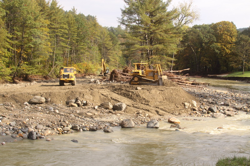
In the downriver direction, the scene was also mysterious and surreal in the foggy morning light, but also with a reality disconnect. Heavy equipment began working to remove sand and rocks from the river bed and put the river "back where it belongs." Rivers have their own life, and I am not sure it really "belongs" any particular place as it moves through the valley. But people have been living in this valley for 200 years and they have made many changes to the river and expect it to respect those changes. Such "respect" might be imposed, but never permanently.

With that philosophical musing out of the way, I am delighted that the work has begun, surreal as it may appear in the foggy light of morning.


The task moves along, and by 10 am, there are noticeable changes. By "putting the river back," there will be protection for roads and bridges in the immediate area and further downstream. Personally, it will also mean that the unstable 20' bluff in the back of my home will be stabilized, protecting property and people.


The same scene as the first photograph at 10:30 am. Though this is very different from the river I have lived with for many years, we are slowly becoming customized to the change. There is greenery, and hints of the changing colors.

Tuesday, September 27, 2011

A Snippet of Hurricane Aftermath & Wildlife

In the beaver pond on Augur Hole Road, just around the corner from my home, I photographed this White-eyed Vireo in early May - a rare bird for Vermont. He sang for several days and then was not heard from. Perhaps he realized that he had strayed out of his range and flew back south. Or perhaps something else happened.

White-eyed Vireo, May, 2011, in a beaver pond in South Newfane
Two weeks after Irene, on September 11, I took the following photograph of the same beaver pond in South Newfane. In the previous photo, I was standing in an alder thicket approximately where the river gravel is exposed in the center of this next photo.

The former beaver pond after Hurricane Irene
We lost 40-50 feet of our property, including our leach field. The area contained several dens, although we have never been able to determine who was using what when. We suspect that there were rotating occupants - groundhog, skunk, raccoon, gray fox, and perhaps others.

Daily visitors in early August included this groundhog ...


Evening visitors included this family of four skunks ...


Did they all get washed away in the flood?

No! The groundhog appears almost daily, looking bigger, fatter, and healthier.

One evening I saw two skunks (for certain) who were cleaning up fallen bird seed. There are not as many birds, so not as much fallen seed. The skunks have apparently moved elsewhere, or at least are not feeding quite as often in the yard. But they survived the flood.

Thursday, September 22, 2011

Blogging post-Irene - 2

About 1/4 mile west of my home, there was a major washout of the Dover Road.
This photo, taken 2 weeks post-Irene on Sunday, Sept 11, show the barely passable reconnection that had been done. Everything from where I am standing to the top of the road rise (where a truck is just visible) had washed out. The stream can just be seen to the middle right, now back to about its original width.


The excavator was working on Sunday to rebuild the river bank and protect the road way, and to provide materials for the rebuilding. One of the astounding tidbits is how much construction equipment there was in the area which could be brought to bear on the recovery efforts.


This is the same roadway seen above, one week later on Sunday, Sept 18. The grader and roller are sitting idle for the first time in almost three weeks. By last Sunday, the equipment operators were getting a well-deserved, and much needed, day of rest.


A half mile to the east of my home, the river changed course. This photo was taken on Sunday, Sept 11. The piles of logs are not from a logging operation. They were trees ripped out by the flood waters and carried down until stopped by some obstacle or jam. The yellow house in the middle is the second story. The house was moved down river 500 feet (it use to stand beyond the middle house in the photo); the first story was beaten apart and washed away. This house may have been the obstacle which stopped the logs, and may be the reason that the new covered bridge another 1/3 mile down river survived.


One week later from almost the same spot - with the roadbed of the Dover Road rebuilt and passable, if the driver has the good sense to go slowly.


On Sunday, Sept 18, this brand new culvert for a small intermittent stream was being completed.


From atop the culvert, an automobile still waits removal, while residents clean their home. Over a foot of silt and mud surround the house, but it appears to have survived. It use to sit in a lovely grassy field.

Tuesday, September 20, 2011

Blogging post-Irene & a bird

The peaceful, gentle, mountain streams which flow through my village of South Newfane became raging rivers with the torrential rains of Hurricane Irene, destroying roads, bridges, homes.

This last week, I spoke with a photographer neighbor about the impossibility of capturing a two dimensional image of the damage. She agreed. To grasp the damage requires three dimensions and 360 degrees. Even so, I have tried.

The recovery work that has been done throughout Vermont is remarkable. All major roads are open (or will be in a few days). In my village heavy construction equipment has worked with remarkable dispatch to restore the roads, although they are still for locals only.

In the previous post, the second photo shows one of the road washouts. Here is the same washout two weeks post-Irene, Sept 11, crews working all day Sunday.


The same stretch of washout was back to grade and passable two days later. If the report I heard (much info goes word of mouth), it will receive the first asphalt in a few more days.


Thousands of yards of material have been needed to rebuild the roads. A few hundred feet east of the previous washout was another large washout. The Rock River (normally just a modest stream) had widened its bed. With the river bed scoured clean, no further environmental damage could be done to aquatic life. Normal regulations were suspended, and building material was taken from the river to rebuild the banks and roadbeds. Here is some of that work being done on
Sunday, Sept 11. Construction trucks such as these are not a normal sight in our neighborhood or roadways.


This next photo shows the same stretch of river bed and roadway seen in the previous photo. This was taken Sunday, Sept 18 - a rough but passable road, with the heavy equipment now working in a different area.


With all of the disruption of the present, I nevertheless took a day off for something normal - a few hours of hawk watching on Putney Mountain. It was Sept 16, the day when Prognosticator Phil guarantees at least 500 migrating hawks. With Golden Eagle and Bald Eagle, a few accipiters and falcons, and a reasonably good flight of Broad-winged Hawks, it was a time of needed mental and emotional therapy.

Broad-winged Hawk - Putney Mountain, September 16
More soon.

Tuesday, September 06, 2011

A Message to Readers/Followers - post Irene

Dear Blog Followers and Tweeters -

Last week for the first time in 12 years, I did not have a column (Tailfeathers) in the Brattleboro Reformer.

Hurricane Irene hit my little village of South Newfane with extreme fury (Photos below), washing out large sections of all roads into the village, destroying and damaging bridges, destroying and damaging many homes. The Rock River and the Marlboro Branch cut new channels and changed course in many places.

I was fortunate. I was in Philadelphia with family. My home had no damage, but about 35 feet of our yard disappeared, including the leach field for our septic system. I made a brief visit to South Newfane last week when a bridge was temporarily made passable and contact with the village reestablished. I will return to Vermont again this week to begin work with an engineer on a new septic system, and to help in the community where possible.

Birding is on hold for the moment. Column writing, blogging, and photography all have writer’s block, blog block, and photo block.

Please be patient. Keep me on your list and check back from time to time.

Chris

The bridge abutment washed out and one end collapsed. But the bridge structure was still sound. Remarkably, this became the place where South Newfane was reconnected with the rest of the state. A sand and gravel ramp was built from the bridge to the road surface. (Photo from the facebook.com/NewfaneBulletin - a page put up a day after the flood to provide information and connection for people)


Dover Road east of the green iron bridge. The river's edge was just to the right of the photo. (Photo from CVPS, I think)


Further east on the Dover Road where the Rock River tried to cut a new oxbow. The river channel, pre-storm, was about 50-60' to the right of the photo (Photo from VPR, I think)


Our backyard along the new river's edge. Pre-storm, the river bank was to the left of the photo, with a huge old willow tree at the bottom left corner, just outside the current photo. The part of the river seen in this photo was a pine covered slope.


From what I have learned, engineers feel the river will want to reclaim its previous bed and that its new banks are unstable. Heavy equipment is working in the river to put the river back in its old banks.

When I have the opportunity I will post a few additional photos, and hopefully before too long, will be back to the birds.

LinkWithin

Related Posts with Thumbnails